Easy fuel gains thanks to oceanic currents
Thanks to this 12 months ESA project, our technology was tested and validated by a few French shipping companies and the fuel savings provided by short-term optimal routing were quantified in the Mediterranean Sea and the Gulf of Mexico. This feasibility study quantifies the performance of short-term optimal routing mode using a new generation of high-resolution surface currents: HIRES-CURRENTS. These oceanic data are obtained by AI fusion of various satellite observations (infrared, visible imagery and AVISO/DUACS altimetry maps).
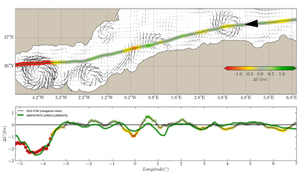
Thanks to the navigation data provided by Louis Dreyfus Armateurs (LDA) and CMA-CGM we were able to quantify precisely the impact of oceanic currents on the ship speed and therefore the accuracy of our forecasts (Figure 1). To quantify the current impacts we compute, along the ship route, the difference between the Speed Through Water (STW) and the Speed Over Ground (SOG) performing specific re-calibration of the speed log when needed.

Figure 1:
Example of the surface currents impact on the ship speed of a 24 000 TEU containership crossing the Alboran Sea in August 2023. Colors indicate acceleration(green)/reduction(red) of the ship speed computed from the difference
U=SOG-STW (in knots). The lower panel shows the comparison, along the ship route, between the navigation data and the current impact estimated by HIRES-CURRENTS forecasts.
Direct comparisons with standard numerical models of ocean circulation were also performed. We demonstrate that the accuracy of our HIRES-CURRENT data goes far beyond operational forecast model in the Mediterranean Sea.
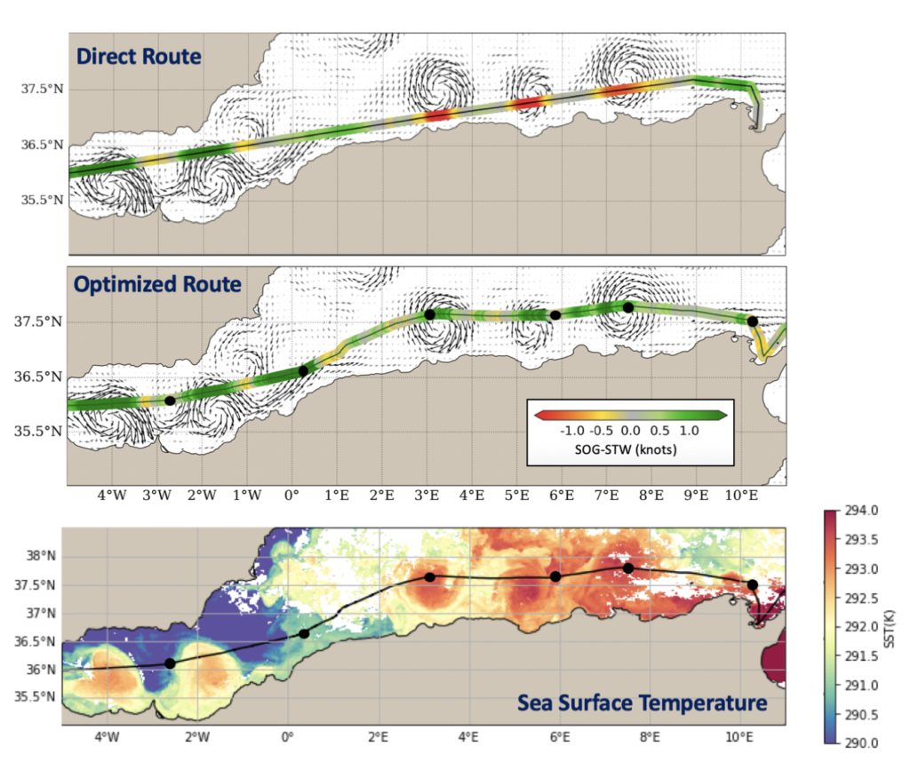
A new form of optimal routing that fully utilizes the potential of ocean currents can provide easy fuel savings for short-sea shipping in the Mediterranean Sea. As illustrated below a Ro-Ro ship traveling along the Algerian coast in November 2023 benefitted from this approach. Initially, its path was hindered by several coastal eddies. Thanks to a short-term optimization —provided a day in advance— the vessel altered its course slightly northward, effectively circumventing the eddies. This minor detour, allowed the ship to save over an hour on this journey and cut fuel consumption by up to 4% by adjusting its arrival speed.

Figure 2:
Example of Short-Term Optimal Routing (STOR) application along Tanger to Tunis route in the Alboran Sea for a Ro-Ro vessel navigating at 16 knots. The background velocities correspond to the HIRES currents as derived for the 26 November 2023. The upper figure shows the current impacts (SOG-STW) on the initial voyage plan for this leg. The middle one shows the speed gains (SOG-STW) on the optimized route followed by the Ciudad de Cadiz for the given day. Black circles corresponds to additional waypoints needed to follow the optimized route. The lower panel shows the correlation with the Sea Surface Temperature.
Short-sea shipping optimal routing can be implemented today, on all ships, without any CAPEX and a ROI up to 4-5.


